
))/3079694.json)
Fish smarter with the help of the information packed inside the National Geographic Fishing and River Recreation Map Guide Series Maps. Each one includes detailed river maps at a scale of 1 for every half mile. At this scale, every bend and
))/4194965.json)
GHG Finisher Series Foam Filled Electronic Ripple Makers- Ultra-realistic detail anatomically perfect body- Foamed-filled decoy body for durability- Built-in quiver adds realistic ripples and motion in spread- Internal watertight battery housing (4AA
))/2326915.json)
Hey hikers, backpackers, and other wilderness explorers, the National Geographic Trails Illustrated Topographic Map Guide Series is the resource you'll want in your backpack while wandering unfamiliar trails. Certified Backcountry Tough, this fold-
))/2151883.json)
Navigate your favorite trails and find new ones to explore with the National Geographic National Forests Trails Illustrated Topographic Map Series. Providing incredible detail, these trail maps areabeled with mileage markers and are color
))/1754553.json)
Navigate your favorite trails and find new ones to explore with the National Geographic National Forests Trails Illustrated Topographic Map Series. Providing incredible detail, these trail maps areabeled with mileage markers and are color
))/984408.json)
Navigate your favorite trails and find new ones to explore with the National Geographic National Forests Trails Illustrated Topographic Map Series. Providing incredible detail, these trail maps areabeled with mileage markers and are color
))/1754548.json)
Navigate your favorite trails and find new ones to explore with the National Geographic National Forests Trails Illustrated Topographic Map Series. Providing incredible detail, these trail maps areabeled with mileage markers and are color
))/1233156.json)
Hey hikers, backpackers, and other wilderness explorers, the National Geographic Trails Illustrated Topographic Map Guide Series is the resource you'll want in your backpack while wandering unfamiliar trails. Certified Backcountry Tough, this fold-
))/1754600.json)
Navigate your favorite trails and find new ones to explore with the National Geographic National Forests Trails Illustrated Topographic Map Series. Providing incredible detail, these trail maps areabeled with mileage markers and are color
))/2000703.json)
Navigate your favorite trails and find new ones to explore with the National Geographic National Forests Trails Illustrated Topographic Map Series. Providing incredible detail, these trail maps areabeled with mileage markers and are color
))/3222466.json)
Hey hikers, backpackers, and other wilderness explorers, the National Geographic Trails Illustrated Topographic Map Guide Series is the resource you'll want in your backpack while wandering unfamiliar trails. Certified Backcountry Tough, this fold-
))/2326944.json)
Navigate your favorite trails and find new ones to explore with the National Geographic National Forests Trails Illustrated Topographic Map Series. Providing incredible detail, these trail maps areabeled with mileage markers and are color
))/984415.json)
Navigate your favorite trails and find new ones to explore with the National Geographic National Forests Trails Illustrated Topographic Map Series. Providing incredible detail, these trail maps areabeled with mileage markers and are color
))/1233116.json)
Hey hikers, backpackers, and other wilderness explorers, the National Geographic Trails Illustrated Topographic Map Guide Series is the resource you'll want in your backpack while wandering unfamiliar trails. Certified Backcountry Tough, this fold-
))/2028186.json)
Navigate your favorite trails and find new ones to explore with the National Geographic National Forests Trails Illustrated Topographic Map Series. Providing incredible detail, these trail maps areabeled with mileage markers and are color
))/984412.json)
Navigate your favorite trails and find new ones to explore with the National Geographic National Forests Trails Illustrated Topographic Map Series. Providing incredible detail, these trail maps areabeled with mileage markers and are color
))/3665183.json)
An easy-to-use power source for all your outdoor activities and more, Cabela's Outdoorsman Series 5,000W/4,000W RV-Ready Dual-Fuel Portable Generator with Electric Start and CO Shield delivers power you need, where you need it. Perfect for p
))/1656093.json)
Navigate your favorite trails and find new ones to explore with the National Geographic National Forests Trails Illustrated Topographic Map Series. Providing incredible detail, these trail maps areabeled with mileage markers and are color
))/984400.json)
Navigate your favorite trails and find new ones to explore with the National Geographic National Forests Trails Illustrated Topographic Map Series. Providing incredible detail, these trail maps areabeled with mileage markers and are color
))/3222468.json)
Hey hikers, backpackers, and other wilderness explorers, the National Geographic Trails Illustrated Topographic Map Guide Series is the resource you'll want in your backpack while wandering unfamiliar trails. Certified Backcountry Tough, this fold-
))/3079697.json)
Fish smarter with the help of the information packed inside the National Geographic Fishing and River Recreation Map Guide Series Maps. Each one includes detailed river maps at a scale of 1 for every half mile. At this scale, every bend and
))/2028187.json)
Navigate your favorite trails and find new ones to explore with the National Geographic National Forests Trails Illustrated Topographic Map Series. Providing incredible detail, these trail maps areabeled with mileage markers and are color
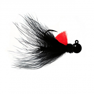
Hawken Marabou Series AeroJigs are designed for salmon or steelhead in any water conditions. These jigs are made using Gamakatsu hooks which are customized with 1/0 wire to ensure superb strength. The heads are powder-painted to ensure a bulletproof,...
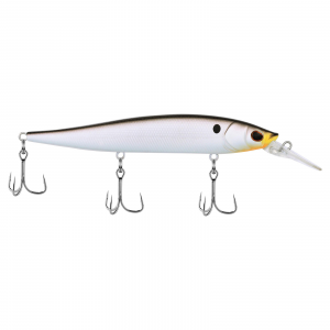
The Berkley Stunna 112 Series Jerkbait comes to you from Bassmaster Classic Champion Hank Cherry's winning modifications to a jerkbait and Berkley's design expertise to drive the bass to strike! The Stunna balances an optimized center of gravity through...
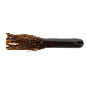
The Gitzit Tournament Series Tube offers a time-tested profile and soft body construction that excels in pressured fisheries, clear water, and finesse scenarios. Anglers use it to skip docks, drag points, or hop it through boulder fields, where the subtle...